
Articles | Volume 1, issue 1
https://doi.org/10.5194/eo-1-105-2026
© Author(s) 2026. This work is distributed under
the Creative Commons Attribution 4.0 License.
the Creative Commons Attribution 4.0 License.
https://doi.org/10.5194/eo-1-105-2026
© Author(s) 2026. This work is distributed under
the Creative Commons Attribution 4.0 License.
the Creative Commons Attribution 4.0 License.
Research article
| 
17 Sep 2026
Research article |
| 17 Sep 2026
| 17 Sep 2026
Evaluation of ASCAT soil moisture retrievals and their potential to detect intraday variability
Estellus, Paris, France
LIRA, Observatoire de Paris, Université PSL, Sorbonne Université, CNRS, Paris, France
Filipe Aires
LIRA, Observatoire de Paris, Université PSL, Sorbonne Université, CNRS, Paris, France
Estellus, Paris, France
Victor Pellet
LMD, École Polytechnique, Palaiseau, France
LIRA, Observatoire de Paris, Université PSL, Sorbonne Université, CNRS, Paris, France
Related authors

Thi Lan Anh Dinh, Daniel Goll, Philippe Ciais, and Ronny Lauerwald
Geosci. Model Dev., 17, 6725–6744, https://doi.org/10.5194/gmd-17-6725-2024, https://doi.org/10.5194/gmd-17-6725-2024, 2024
Short summary
Short summary
The study assesses the performance of the dynamic global vegetation model (DGVM) ORCHIDEE in capturing the impact of land-use change on carbon stocks across Europe. Comparisons with observations reveal that the model accurately represents carbon fluxes and stocks. Despite the underestimations in certain land-use conversions, the model describes general trends in soil carbon response to land-use change, aligning with the site observations.
Thi Lan Anh Dinh and Filipe Aires
Geosci. Model Dev., 15, 3519–3535, https://doi.org/10.5194/gmd-15-3519-2022, https://doi.org/10.5194/gmd-15-3519-2022, 2022
Short summary
Short summary
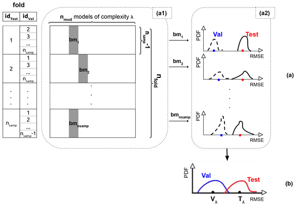
We proposed the leave-two-out method (i.e. one particular implementation of the nested cross-validation) to determine the optimal statistical crop model (using the validation dataset) and estimate its true generalization ability (using the testing dataset). This approach is applied to two examples (robusta coffee in Cu M'gar and grain maize in France). The results suggested that the simple models are more suitable in crop modelling where a limited number of samples is available.
Man Chen, Philippe Ciais, Gustaf Hugelius, and Filipe Aires
Earth Syst. Sci. Data Discuss., https://doi.org/10.5194/essd-2026-254, https://doi.org/10.5194/essd-2026-254, 2026
Preprint under review for ESSD
Short summary
Short summary
Peatlands are vital carbon stores, yet mapping them consistently across borders is challenging due to varying data quality and definitions. We developed PeatCover, a ~90 m resolution map that harmonizes existing inventories with Earth observation and hydro-topographic data through machine learning. PeatCover provides a spatially coherent dataset that resolves fine landscape structures. These improvements enable refined carbon assessments and methane emission models.
Bernhard Lehner, Mira Anand, Etienne Fluet-Chouinard, Florence Tan, Filipe Aires, George H. Allen, Philippe Bousquet, Josep G. Canadell, Nick Davidson, Meng Ding, C. Max Finlayson, Thomas Gumbricht, Lammert Hilarides, Gustaf Hugelius, Robert B. Jackson, Maartje C. Korver, Liangyun Liu, Peter B. McIntyre, Szabolcs Nagy, David Olefeldt, Tamlin M. Pavelsky, Jean-Francois Pekel, Benjamin Poulter, Catherine Prigent, Jida Wang, Thomas A. Worthington, Dai Yamazaki, Xiao Zhang, and Michele Thieme
Earth Syst. Sci. Data, 17, 2277–2329, https://doi.org/10.5194/essd-17-2277-2025, https://doi.org/10.5194/essd-17-2277-2025, 2025
Short summary
Short summary
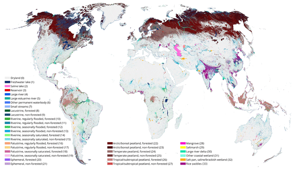
The Global Lakes and Wetlands Database (GLWD) version 2 distinguishes a total of 33 non-overlapping wetland classes, providing a static map of the world’s inland surface waters. It contains cell fractions of wetland extents per class at a grid cell resolution of ~500 m. The total combined extent of all classes including all inland and coastal waterbodies and wetlands of all inundation frequencies – that is, the maximum extent – covers 18.2 × 10⁶ km2, equivalent to 13.4 % of total global land area.
Thi Lan Anh Dinh, Daniel Goll, Philippe Ciais, and Ronny Lauerwald
Geosci. Model Dev., 17, 6725–6744, https://doi.org/10.5194/gmd-17-6725-2024, https://doi.org/10.5194/gmd-17-6725-2024, 2024
Short summary
Short summary
The study assesses the performance of the dynamic global vegetation model (DGVM) ORCHIDEE in capturing the impact of land-use change on carbon stocks across Europe. Comparisons with observations reveal that the model accurately represents carbon fluxes and stocks. Despite the underestimations in certain land-use conversions, the model describes general trends in soil carbon response to land-use change, aligning with the site observations.
Thi Lan Anh Dinh and Filipe Aires
Geosci. Model Dev., 15, 3519–3535, https://doi.org/10.5194/gmd-15-3519-2022, https://doi.org/10.5194/gmd-15-3519-2022, 2022
Short summary
Short summary
We proposed the leave-two-out method (i.e. one particular implementation of the nested cross-validation) to determine the optimal statistical crop model (using the validation dataset) and estimate its true generalization ability (using the testing dataset). This approach is applied to two examples (robusta coffee in Cu M'gar and grain maize in France). The results suggested that the simple models are more suitable in crop modelling where a limited number of samples is available.
Marie Bouillon, Sarah Safieddine, Simon Whitburn, Lieven Clarisse, Filipe Aires, Victor Pellet, Olivier Lezeaux, Noëlle A. Scott, Marie Doutriaux-Boucher, and Cathy Clerbaux
Atmos. Meas. Tech., 15, 1779–1793, https://doi.org/10.5194/amt-15-1779-2022, https://doi.org/10.5194/amt-15-1779-2022, 2022
Short summary
Short summary
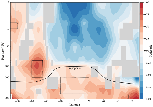
The IASI instruments have been observing Earth since 2007. We use a neural network to retrieve atmospheric temperatures. This new temperature data record is validated against other datasets and shows good agreement. We use this new dataset to compute trends over the 2008–2020 period. We found a warming of the troposphere, more important at the poles. In the stratosphere, we found that temperatures decrease everywhere except at the South Pole. The cooling is more pronounced at the South pole.
Cited articles
Abbaszadeh, P., Moradkhani, H., and Zhan, X.: Downscaling SMAP Radiometer Soil Moisture Over the CONUS Using an Ensemble Learning Method, Water Resour. Res., 55, 324–344, https://doi.org/10.1029/2018WR023354, 2019. a
Aires, F., Prigent, C., Rossow, W. B., and Rothstein, M.: A new neural network approach including first guess for retrieval of atmospheric water vapor, cloud liquid water path, surface temperature, and emissivities over land from satellite microwave observations, J. Geophys. Res.-Atmos., 106, 14887–14907, https://doi.org/10.1029/2001JD900085, 2001. a, b, c, d
Aires, F., Prigent, C., and Rossow, W. B.: Sensitivity of satellite microwave and infrared observations to soil moisture at a global scale: 2. Global statistical relationships, J. Geophys. Res.-Atmos., 110, https://doi.org/10.1029/2004JD005094, 2005. a
Aires, F., Boucher, E., and Pellet, V.: Convolutional neural networks for satellite remote sensing at coarse resolution. Application for the SST retrieval using IASI, Remote Sens. Environ., 263, 112553, https://doi.org/10.1016/j.rse.2021.112553, 2021a. a, b, c, d
Aires, F., Weston, P., de Rosnay, P., and Fairbairn, D.: Statistical approaches to assimilate ASCAT soil moisture information – I. Methodologies and first assessment, Q. J. Roy. Meteor. Soc., 147, 1823–1852, https://doi.org/10.1002/qj.3997, 2021b. a, b
Araya, S. N., Fryjoff-Hung, A., Anderson, A., Viers, J. H., and Ghezzehei, T. A.: Advances in soil moisture retrieval from multispectral remote sensing using unoccupied aircraft systems and machine learning techniques, Hydrol. Earth Syst. Sci., 25, 2739–2758, https://doi.org/10.5194/hess-25-2739-2021, 2021. a
Bartalis, Z., Wagner, W., Naeimi, V., Hasenauer, S., Scipal, K., Bonekamp, H., Figa, J., and Anderson, C.: Initial soil moisture retrievals from the METOP-A Advanced Scatterometer (ASCAT), Geophys. Res. Lett., 34, https://doi.org/10.1029/2007GL031088, 2007. a
Batchu, V., Nearing, G., and Gulshan, V.: A Deep Learning Data Fusion Model Using Sentinel-1/2, SoilGrids, SMAP, and GLDAS for Soil Moisture Retrieval, J. Hydrometeorol., 24, 1789–1823, https://doi.org/10.1175/JHM-D-22-0118.1, 2023. a
Bateni, S. M. and Entekhabi, D.: Relative efficiency of land surface energy balance components, Water Resour. Res., 48, https://doi.org/10.1029/2011WR011357, 2012. a
Bell, J. E., Palecki, M. A., Baker, C. B., Collins, W. G., Lawrimore, J. H., Leeper, R. D., Hall, M. E., Kochendorfer, J., Meyers, T. P., Wilson, T., and Diamond, H. J.: U.S. Climate Reference Network Soil Moisture and Temperature Observations, J. Hydrometeorol., 14, 977–988, https://doi.org/10.1175/JHM-D-12-0146.1, 2013. a
Bernhardt, J., Carleton, A. M., and LaMagna, C.: A Comparison of Daily Temperature-Averaging Methods: Spatial Variability and Recent Change for the CONUS, J. Climate, 31, 979–996, https://doi.org/10.1175/JCLI-D-17-0089.1, 2018. a, b
Boucher, E. and Aires, F.: Improving remote sensing of extreme events with machine learning: land surface temperature retrievals from IASI observations, Environ. Res. Lett., 18, 024025, https://doi.org/10.1088/1748-9326/acb3e3, 2023. a
Boucher, E., Aires, F., and Pellet, V.: Towards a new generation of artificial-intelligence-based infrared atmospheric sounding interferometer retrievals of surface temperature: Part I – Methodology, Q. J. Roy. Meteor. Soc., 149, 1180–1196, https://doi.org/10.1002/qj.4447, 2023. a
Brocca, L., Melone, F., Moramarco, T., Wagner, W., Naeimi, V., Bartalis, Z., and Hasenauer, S.: Improving runoff prediction through the assimilation of the ASCAT soil moisture product, Hydrol. Earth Syst. Sci., 14, 1881–1893, https://doi.org/10.5194/hess-14-1881-2010, 2010. a
Campbell, G. S.: Soil Physics with Basic: Transport Models for Soil-Plant Systems, Elsevier, Amsterdam, ISBN 978-0-444-42557-7, 1985. a
Chen, Y., López-Moreno, I., Sainath, T. N., Visontai, M., Álvarez, R., and Parada, C.: Locally-connected and convolutional neural networks for small footprint speaker recognition, in: Interspeech, https://api.semanticscholar.org/CorpusID:6623788 (last access: 25 January 2025), 2015. a
Dinh, L. A.: ASCAT soil moisture retrieval using deep learning: A focus on localization strategy, Front. Remote Sens., 6, https://doi.org/10.3389/frsen.2025.1718353, 2026. a, b, c
Dorigo, W., Xaver, A., Vreugdenhil, M., Gruber, A., Dostálová, A., Sanchis-Dufau, A. D., Zamojski, D., Cordes, C., Wagner, W., and Drusch, M.: Global Automated Quality Control of In Situ Soil Moisture Data from the International Soil Moisture Network, Vadose Zone J., 12, vzj2012.0097, https://doi.org/10.2136/vzj2012.0097, 2013. a, b
Dorigo, W., Wagner, W., Albergel, C., Albrecht, F., Balsamo, G., Brocca, L., Chung, D., Ertl, M., Forkel, M., Gruber, A., Haas, E., Hamer, P. D., Hirschi, M., Ikonen, J., de Jeu, R., Kidd, R., Lahoz, W., Liu, Y. Y., Miralles, D., Mistelbauer, T., Nicolai-Shaw, N., Parinussa, R., Pratola, C., Reimer, C., van der Schalie, R., Seneviratne, S. I., Smolander, T., and Lecomte, P.: ESA CCI Soil Moisture for improved Earth system understanding: State-of-the art and future directions, Remote Sens. Environ., 203, 185–215, https://doi.org/10.1016/j.rse.2017.07.001, 2017. a
Dorigo, W., Himmelbauer, I., Aberer, D., Schremmer, L., Petrakovic, I., Zappa, L., Preimesberger, W., Xaver, A., Annor, F., Ardö, J., Baldocchi, D., Bitelli, M., Blöschl, G., Bogena, H., Brocca, L., Calvet, J.-C., Camarero, J. J., Capello, G., Choi, M., Cosh, M. C., van de Giesen, N., Hajdu, I., Ikonen, J., Jensen, K. H., Kanniah, K. D., de Kat, I., Kirchengast, G., Kumar Rai, P., Kyrouac, J., Larson, K., Liu, S., Loew, A., Moghaddam, M., Martínez Fernández, J., Mattar Bader, C., Morbidelli, R., Musial, J. P., Osenga, E., Palecki, M. A., Pellarin, T., Petropoulos, G. P., Pfeil, I., Powers, J., Robock, A., Rüdiger, C., Rummel, U., Strobel, M., Su, Z., Sullivan, R., Tagesson, T., Varlagin, A., Vreugdenhil, M., Walker, J., Wen, J., Wenger, F., Wigneron, J. P., Woods, M., Yang, K., Zeng, Y., Zhang, X., Zreda, M., Dietrich, S., Gruber, A., van Oevelen, P., Wagner, W., Scipal, K., Drusch, M., and Sabia, R.: The International Soil Moisture Network: serving Earth system science for over a decade, Hydrol. Earth Syst. Sci., 25, 5749–5804, https://doi.org/10.5194/hess-25-5749-2021, 2021 (data available at: https://ismn.earth/en/data/, last access: 3 March 2025). a, b, c
Duveiller, G., Pickering, M., Muñoz-Sabater, J., Caporaso, L., Boussetta, S., Balsamo, G., and Cescatti, A.: Getting the leaves right matters for estimating temperature extremes, Geosci. Model Dev., 16, 7357–7373, https://doi.org/10.5194/gmd-16-7357-2023, 2023. a
El Hajj, M., Baghdadi, N., Zribi, M., Belaud, G., Cheviron, B., Courault, D., and Charron, F.: Soil moisture retrieval over irrigated grassland using X-band SAR data, Remote Sens. Environ., 176, 202–218, https://doi.org/10.1016/j.rse.2016.01.027, 2016. a
Entekhabi, D., Njoku, E. G., O'Neill, P. E., Kellogg, K. H., Crow, W. T., Edelstein, W. N., Entin, J. K., Goodman, S. D., Jackson, T. J., Johnson, J., Kimball, J., Piepmeier, J. R., Koster, R. D., Martin, N., McDonald, K. C., Moghaddam, M., Moran, S., Reichle, R., Shi, J. C., Spencer, M. W., Thurman, S. W., Tsang, L., and Van Zyl, J.: The Soil Moisture Active Passive (SMAP) Mission, P. IEEE, 98, 704–716, https://doi.org/10.1109/JPROC.2010.2043918, 2010. a
EUMETSAT H SAF: ASCAT Surface Soil Moisture Climate Data Record v7 12.5 km sampling – Metop, EUMETSAT [data set], https://doi.org/10.15770/EUM_SAF_H_0009, 2021. a, b, c
Figa-Saldaña, J., Wilson, J. J., Attema, E., Gelsthorpe, R., Drinkwater, M. R., and and, A. S.: The advanced scatterometer (ASCAT) on the meteorological operational (MetOp) platform: A follow on for European wind scatterometers, Can. J. Remote Sens., 28, 404–412, https://doi.org/10.5589/m02-035, 2002. a
Ghanbari, H., Mahdianpari, M., Homayouni, S., and Mohammadimanesh, F.: A Meta-Analysis of Convolutional Neural Networks for Remote Sensing Applications, IEEE J. Sel. Top. Appl., 14, 3602–3613, https://doi.org/10.1109/JSTARS.2021.3065569, 2021. a
Goodfellow, I., Bengio, Y., and Courville, A.: Deep Learning, MIT Press, http://www.deeplearningbook.org (last access: 15 January 2025), 2016. a
Han, Q., Zeng, Y., Zhang, L., Wang, C., Prikaziuk, E., Niu, Z., and Su, B.: Global long term daily 1 km surface soil moisture dataset with physics informed machine learning, Sci. Data, 10, 101, https://doi.org/10.1038/s41597-023-02011-7, 2023. a, b, c
Hastie, T., Tibshirani, R., and Friedman, J.: Neural Networks, Springer New York, New York, NY, 389–416, ISBN 978-0-387-84858-7, https://doi.org/10.1007/978-0-387-84858-7_11, 2009. a, b, c
Hersbach, H., Bell, B., Berrisford, P., Biavati, G., Horányi, A., Muñoz Sabater, J., Nicolas, J., Peubey, C., Radu, R., Rozum, I., Schepers, D., Simmons, A., Soci, C., Dee, D., and Thépaut, J.-N.: ERA5 hourly data on single levels from 1940 to present, Copernicus Climate Change Service (C3S) Climate Data Store (CDS) [data set], https://doi.org/10.24381/cds.adbb2d47, 2023. a, b
Hinton, G., Deng, L., Yu, D., Dahl, G. E., Mohamed, A.-R., Jaitly, N., Senior, A., Vanhoucke, V., Nguyen, P., Sainath, T. N., and Kingsbury, B.: Deep Neural Networks for Acoustic Modeling in Speech Recognition: The Shared Views of Four Research Groups, IEEE Signal Proc. Mag., 29, 82–97, https://doi.org/10.1109/MSP.2012.2205597, 2012. a
Hong, D., Zhang, B., Li, X., Li, Y., Li, C., Yao, J., Yokoya, N., Li, H., Ghamisi, P., Jia, X., Plaza, A., Gamba, P., Benediktsson, J. A., and Chanussot, J.: SpectralGPT: Spectral Remote Sensing Foundation Model, IEEE T. Pattern Anal., 46, 5227–5244, https://doi.org/10.1109/TPAMI.2024.3362475, 2024. a
Kerr, Y. H., Waldteufel, P., Wigneron, J.-P., Delwart, S., Cabot, F., Boutin, J., Escorihuela, M.-J., Font, J., Reul, N., Gruhier, C., Juglea, S. E., Drinkwater, M. R., Hahne, A., Martín-Neira, M., and Mecklenburg, S.: The SMOS Mission: New Tool for Monitoring Key Elements ofthe Global Water Cycle, P. IEEE, 98, 666–687, https://doi.org/10.1109/JPROC.2010.2043032, 2010. a
Kim, H., Lakshmi, V., Kwon, Y., and Kumar, S. V.: First attempt of global-scale assimilation of subdaily scale soil moisture estimates from CYGNSS and SMAP into a land surface model, Environ. Res. Lett., 16, 074041, https://doi.org/10.1088/1748-9326/ac0ddf, 2021. a
Kingma, D. P. and Ba, J.: Adam: A Method for Stochastic Optimization, arXiv [preprint], https://doi.org/10.48550/arXiv.1412.6980, 2017. a
Kolassa, J., Aires, F., Polcher, J., Prigent, C., Jimenez, C., and Pereira, J. M.: Soil moisture retrieval from multi-instrument observations: Information content analysis and retrieval methodology, J. Geophys. Res.-Atmos., 118, 4847–4859, https://doi.org/10.1029/2012JD018150, 2013. a, b
Kolassa, J., Gentine, P., Prigent, C., Aires, F., and Alemohammad, S.: Soil moisture retrieval from AMSR-E and ASCAT microwave observation synergy. Part 2: Product evaluation, Remote Sens. Environ., 195, 202–217, https://doi.org/10.1016/j.rse.2017.04.020, 2017. a
Leavesley, G. H., David, O., Garen, D. C., Nrcs-Usda, N., Goodbody, A. G., Lea, J. K., Marron, J. K., and Strobel, M.: A modeling framework for improved agricultural water-supply forecasting, https://api.semanticscholar.org/CorpusID:129416417 (last access: 3 March 2025), 2010. a
Lecun, Y., Bottou, L., Bengio, Y., and Haffner, P.: Gradient-based learning applied to document recognition, P. IEEE, 86, 2278–2324, https://doi.org/10.1109/5.726791, 1998. a
Maggiori, E., Tarabalka, Y., Charpiat, G., and Alliez, P.: Convolutional Neural Networks for Large-Scale Remote-Sensing Image Classification, IEEE T. Geosci. Remote, 55, 645–657, https://doi.org/10.1109/TGRS.2016.2612821, 2017. a
McColl, K. A., Alemohammad, S. H., Akbar, R., Konings, A. G., Yueh, S., and Entekhabi, D.: The global distribution and dynamics of surface soil moisture, Nat. Geosci., 10, 100–104, https://doi.org/10.1038/ngeo2868, 2017. a
Myneni, R., Knyazikhin, Y., and Park, T.: MCD15A3H MODIS/Terra+Aqua Leaf Area Index/FPAR 4-day L4 Global 500m SIN Grid V006, NASA Land Processes Distributed Active Archive Center, https://doi.org/10.5067/MODIS/MCD15A3H.006, 2015. a
Nair, V. and Hinton, G. E.: Rectified linear units improve restricted boltzmann machines, in: Proceedings of the 27th International Conference on International Conference on Machine Learning, ICML'10, Omnipress, Madison, WI, USA, 807–814, ISBN 9781605589077, 2010. a
O, S. and Orth, R.: Global soil moisture from in-situ measurements using machine learning – SoMo.ml, arXiv [preprint], https://doi.org/10.48550/arXiv.2010.02374, 2020. a
Ochsner, T. E., Cosh, M. H., Cuenca, R. H., Dorigo, W. A., Draper, C. S., Hagimoto, Y., Kerr, Y. H., Larson, K. M., Njoku, E. G., Small, E. E., and Zreda, M.: State of the Art in Large-Scale Soil Moisture Monitoring, Soil Sci. Soc. Am. J., 77, 1888–1919, https://doi.org/10.2136/sssaj2013.03.0093, 2013. a
Petchiappan, A., Steele-Dunne, S. C., Vreugdenhil, M., Hahn, S., Wagner, W., and Oliveira, R.: The influence of vegetation water dynamics on the ASCAT backscatter–incidence angle relationship in the Amazon, Hydrol. Earth Syst. Sci., 26, 2997–3019, https://doi.org/10.5194/hess-26-2997-2022, 2022. a
Prigent, C., Aires, F., Rossow, W. B., and Robock, A.: Sensitivity of satellite microwave and infrared observations to soil moisture at a global scale: Relationship of satellite observations to in situ soil moisture measurements, J. Geophys. Res.-Atmos., 110, https://doi.org/10.1029/2004JD005087, 2005. a
Rabiei, S., Babaeian, E., and Grunwald, S.: Surface and Subsurface Soil Moisture Estimation Using Fusion of SMAP, NLDAS-2, and SOLUS100 Data with Deep Learning, Remote Sens., 17, https://doi.org/10.3390/rs17040659, 2025. a, b
Rezaee, M., Mahdianpari, M., Zhang, Y., and Salehi, B.: Deep Convolutional Neural Network for Complex Wetland Classification Using Optical Remote Sensing Imagery, IEEE J. Sel. Top. Appl., 11, 3030–3039, https://doi.org/10.1109/JSTARS.2018.2846178, 2018. a
Rodell, M., Houser, P. R., Jambor, U., Gottschalck, J., Mitchell, K., Meng, C.-J., Arsenault, K., Cosgrove, B., Radakovich, J., Bosilovich, M., Entin, J. K., Walker, J. P., Lohmann, D., and Toll, D.: The Global Land Data Assimilation System, B. Am. Meteor. Soc., 85, 381–394, https://doi.org/10.1175/BAMS-85-3-381, 2004 (data available at: https://ldas.gsfc.nasa.gov/gldas/soils, last access: 31 May 2025). a, b
Rodríguez-Fernández, N., de Rosnay, P., Albergel, C., Richaume, P., Aires, F., Prigent, C., and Kerr, Y.: SMOS Neural Network Soil Moisture Data Assimilation in a Land Surface Model and Atmospheric Impact, Remote Sens., 11, https://doi.org/10.3390/rs11111334, 2019. a, b
Rodríguez-Fernández, N. J., de Souza, V., Kerr, Y. H., Richaume, P., and Al Bitar, A.: Soil moisture retrieval using SMOS brightness temperatures and a neural network trained on in situ measurements, in: 2017 IEEE International Geoscience and Remote Sensing Symposium (IGARSS), 1574–1577, https://doi.org/10.1109/IGARSS.2017.8127271, 2017. a
Samadzadegan, F., Toosi, A., and Javan, F. D.: A critical review on multi-sensor and multi-platform remote sensing data fusion approaches: current status and prospects, Int. J. Remote Sens., 46, 1327–1402, https://doi.org/10.1080/01431161.2024.2429784, 2025. a
Saxton, K. E. and Rawls, W. J.: Soil Water Characteristic Estimates by Texture and Organic Matter for Hydrologic Solutions, Soil Sci. Soc. Am. J., 70, 1569–1578, https://doi.org/10.2136/sssaj2005.0117, 2006. a
Schaefer, G. L., Cosh, M. H., and Jackson, T. J.: The USDA Natural Resources Conservation Service Soil Climate Analysis Network (SCAN), J. Atmos. Ocean. Tech., 24, 2073–2077, https://doi.org/10.1175/2007JTECHA930.1, 2007. a
Singh, A. and Gaurav, K.: Deep learning and data fusion to estimate surface soil moisture from multi-sensor satellite images, Sci. Rep., 13, 2251, https://doi.org/10.1038/s41598-023-28939-9, 2023. a
Skafte, N., Jø rgensen, M., and Hauberg, S. r.: Reliable training and estimation of variance networks, in: Advances in Neural Information Processing Systems, edited by: Wallach, H., Larochelle, H., Beygelzimer, A., d'Alché-Buc, F., Fox, E., and Garnett, R., vol. 32, Curran Associates, Inc., https://proceedings.neurips.cc/paper_files/paper/2019/file/07211688a0869d995947a8fb11b215d6-Paper.pdf (last access: 31 March 2025), 2019. a
Srivastava, H. S., Patel, P., Sharma, Y., and Navalgund, R. R.: Large-Area Soil Moisture Estimation Using Multi-Incidence-Angle RADARSAT-1 SAR Data, IEEE T. Geosci. Remote, 47, 2528–2535, https://doi.org/10.1109/TGRS.2009.2018448, 2009. a
Trenberth, K. E., Smith, L., Qian, T., Dai, A., and Fasullo, J.: Estimates of the Global Water Budget and Its Annual Cycle Using Observational and Model Data, J. Hydrometeorol., 8, 758–769, https://doi.org/10.1175/JHM600.1, 2007. a
U.S. Geological Survey (USGS): Annual NLCD Collection 1 Science Products (ver. 1.1, June 2025), U.S. Geological Survey data release [data set], https://doi.org/10.5066/P94UXNTS, 2024. a, b
Vermunt, P. C., Steele-Dunne, S. C., Khabbazan, S., Judge, J., and van de Giesen, N. C.: Extrapolating continuous vegetation water content to understand sub-daily backscatter variations, Hydrol. Earth Syst. Sci., 26, 1223–1241, https://doi.org/10.5194/hess-26-1223-2022, 2022. a, b
Vilà-Guerau de Arellano, J., Ney, P., Hartogensis, O., de Boer, H., van Diepen, K., Emin, D., de Groot, G., Klosterhalfen, A., Langensiepen, M., Matveeva, M., Miranda-García, G., Moene, A. F., Rascher, U., Röckmann, T., Adnew, G., Brüggemann, N., Rothfuss, Y., and Graf, A.: CloudRoots: integration of advanced instrumental techniques and process modelling of sub-hourly and sub-kilometre land–atmosphere interactions, Biogeosciences, 17, 4375–4404, https://doi.org/10.5194/bg-17-4375-2020, 2020. a, b
Wagner, W., Lemoine, G., and Rott, H.: A Method for Estimating Soil Moisture from ERS Scatterometer and Soil Data, Remote Sens. Environ., 70, 191–207, https://doi.org/10.1016/S0034-4257(99)00036-X, 1999a. a, b
Wagner, W., Noll, J., Borgeaud, M., and Rott, H.: Monitoring soil moisture over the Canadian Prairies with the ERS scatterometer, IEEE T. Geosci. Remote, 37, 206–216, https://doi.org/10.1109/36.739155, 1999b. a
Wagner, W., Hahn, S., Kidd, R., Melzer, T., Bartalis, Z., Hasenauer, S., Figa-Saldaña, J., de Rosnay, P., Jann, A., Schneider, S., Komma, J., Kubu, G., Brugger, K., Aubrecht, C., Züger, J., Gangkofner, U., Kienberger, S., Brocca, L., Wang, Y., Blöschl, G., Eitzinger, J., and Steinnocher, K.: The ASCAT Soil Moisture Product: A Review of its Specifications, Validation Results, and Emerging Applications, Meteorol. Z., 22, 5–33, https://doi.org/10.1127/0941-2948/2013/0399, 2013. a
Wang, J., Zhang, Y., Song, P., and Tian, J.: Estimating sub-daily resolution soil moisture using Fengyun satellite data and machine learning, J. Hydrol., 632, 130814, https://doi.org/10.1016/j.jhydrol.2024.130814, 2024. a
Yan, K., Wang, J., Peng, R., Yang, K., Chen, X., Yin, G., Dong, J., Weiss, M., Pu, J., and Myneni, R. B.: HiQ-LAI: a high-quality reprocessed MODIS leaf area index dataset with better spatiotemporal consistency from 2000 to 2022, Earth Syst. Sci. Data, 16, 1601–1622, https://doi.org/10.5194/essd-16-1601-2024, 2024. a
Yao, P., Lu, H., Shi, J., Zhao, T., Yang, K., Cosh, M. H., Gianotti, D. J. S., and Entekhabi, D.: A long term global daily soil moisture dataset derived from AMSR-E and AMSR2 (2002–2019), Sci. Data, 8, 143, https://doi.org/10.1038/s41597-021-00925-8, 2021. a
Yu, Z., Idris, M. Y. I., Wang, H., Wang, P., Chen, J., and Wang, K.: From Physics to Foundation Models: A Review of AI-Driven Quantitative Remote Sensing Inversion, arXiv [preprint], https://doi.org/10.48550/arXiv.2507.09081, 2025. a
Zhang, J., Howard, K., Langston, C., Kaney, B., Qi, Y., Tang, L., Grams, H., Wang, Y., Cocks, S., Martinaitis, S., Arthur, A., Cooper, K., Brogden, J., and Kitzmiller, D.: Multi-Radar Multi-Sensor (MRMS) Quantitative Precipitation Estimation: Initial Operating Capabilities, B. Am. Meteor. Soc., 97, 621–638, https://doi.org/10.1175/BAMS-D-14-00174.1, 2016 (data available at: https://mtarchive.geol.iastate.edu/, last access: 20 August 2026) a, b
Zhang, S.-W., Qiu, C.-J., and Xu, Q.: Estimating Soil Water Contents from Soil Temperature Measurements by Using an Adaptive Kalman Filter, J. Appl. Meteorol., 43, 379–389, https://doi.org/10.1175/1520-0450(2004)043<0379:ESWCFS>2.0.CO;2, 2004. a
Short summary
Soil moisture (SM) plays a key role in weather, agriculture, and water management. While satellites can measure SM from space, obtaining accurate, frequent measurements throughout the day remains challenging. Here, we explore how deep learning models can improve sub-daily SM estimates. Our approach focuses on capturing spatial patterns and adapting to local conditions. Using data from the Advanced SCATterometer (ASCAT) satellite instrument, we show that this model can produce reliable SM estimates multiple times a day.
Soil moisture (SM) plays a key role in weather, agriculture, and water management. While...


