
Articles | Volume 1, issue 1
https://doi.org/10.5194/eo-1-195-2026
© Author(s) 2026. This work is distributed under
the Creative Commons Attribution 4.0 License.
the Creative Commons Attribution 4.0 License.
https://doi.org/10.5194/eo-1-195-2026
© Author(s) 2026. This work is distributed under
the Creative Commons Attribution 4.0 License.
the Creative Commons Attribution 4.0 License.
Research article
| 
19 Nov 2026
Research article |
| 19 Nov 2026
| 19 Nov 2026
Lessons learned from UAV surveys over drifting sea ice at high latitudes

Alfred-Wegener-Institut, Helmholtz-Zentrum für Polar- und Meeresforschung, Bremerhaven, Germany
Niels Fuchs
Institute of Oceanography, University of Hamburg, Hamburg, Germany
Jonathan Kolar
Institute of Earth Sciences, University of Lausanne, Lausanne, Switzerland
Thomas Kordes
Alfred-Wegener-Institut, Helmholtz-Zentrum für Polar- und Meeresforschung, Bremerhaven, Germany
Christian Haas
Alfred-Wegener-Institut, Helmholtz-Zentrum für Polar- und Meeresforschung, Bremerhaven, Germany
Institute for Environmental Physics, University of Bremen, Bremen, Germany
Related authors
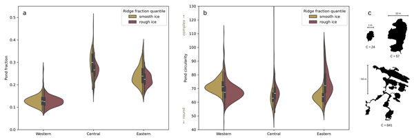
Lena G. Buth, Thomas Krumpen, Niklas Neckel, Melinda A. Webster, Gerit Birnbaum, Niels Fuchs, Philipp Heuser, Ole Johannsen, and Christian Haas
The Cryosphere, 19, 6527–6545, https://doi.org/10.5194/tc-19-6527-2025, https://doi.org/10.5194/tc-19-6527-2025, 2025
Short summary
Short summary
Arctic sea ice is becoming smoother, raising the question of how these changes affect melt pond coverage and thereby surface albedo. Using airborne imagery and laser altimeter data, we investigated how pressure ridges influence melt ponds. The presence of ridges does not directly control pond fraction, but it does influence pond size distribution and pond geometry. Small ponds have a more complex shape on rough ice than on smooth ice, while the opposite is true for large ponds.
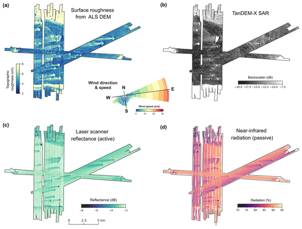
Steven Franke, Mara Neudert, Veit Helm, Arttu Jutila, Océane Hames, Niklas Neckel, Stefanie Arndt, and Christian Haas
The Cryosphere, 19, 6319–6339, https://doi.org/10.5194/tc-19-6319-2025, https://doi.org/10.5194/tc-19-6319-2025, 2025
Short summary
Short summary
Our research explored how icebergs affect the distribution of snow and flooding on Antarctic coastal sea ice. Using aircraft-based radar and laser scanning, we found that icebergs create thick snow drifts on their wind-facing sides and leave snow-free zones in their lee. The weight of these snow drifts often causes the ice below to flood, forming slush. These patterns, driven by wind and iceberg placement, are crucial for understanding sea ice changes and improving climate models.
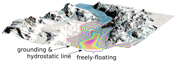
Christian T. Wild, Reinhard Drews, Niklas Neckel, Joohan Lee, Sihyung Kim, Hyangsun Han, Won Sang Lee, Veit Helm, Sebastian Harry Reid Rosier, Oliver J. Marsh, and Wolfgang Rack
The Cryosphere, 19, 4533–4554, https://doi.org/10.5194/tc-19-4533-2025, https://doi.org/10.5194/tc-19-4533-2025, 2025
Short summary
Short summary
The stability of the Antarctic Ice Sheet depends on how resistance along the sides of large glaciers slows down the flow of ice into the ocean. We present a method to map ice strength using the effect of ocean tides on floating ice shelves. Incorporating weaker ice in shear zones improves the accuracy of model predictions, compared with satellite observations. This demonstrates the untapped potential of radar satellites to map ice stiffness in the most critical areas for ice sheet stability.
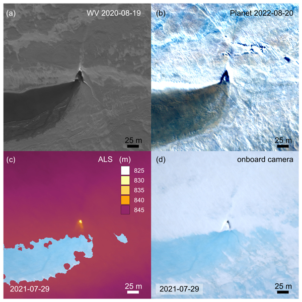
Angelika Humbert, Veit Helm, Ole Zeising, Niklas Neckel, Matthias H. Braun, Shfaqat Abbas Khan, Martin Rückamp, Holger Steeb, Julia Sohn, Matthias Bohnen, and Ralf Müller
The Cryosphere, 19, 3009–3032, https://doi.org/10.5194/tc-19-3009-2025, https://doi.org/10.5194/tc-19-3009-2025, 2025
Short summary
Short summary
We study the evolution of a massive lake on the Greenland Ice Sheet using satellite and airborne data and some modelling. The lake is emptying rapidly. Water flows to the glacier's base through cracks and triangular-shaped moulins that remain visible over the years. Some of them become reactivated. We find features inside the glacier that stem from drainage events with a width of even 1 km. These features are persistent over the years, although they are changing in shape.
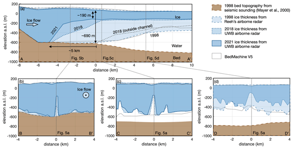
Ole Zeising, Niklas Neckel, Nils Dörr, Veit Helm, Daniel Steinhage, Ralph Timmermann, and Angelika Humbert
The Cryosphere, 18, 1333–1357, https://doi.org/10.5194/tc-18-1333-2024, https://doi.org/10.5194/tc-18-1333-2024, 2024
Short summary
Short summary
The 79° North Glacier in Greenland has experienced significant changes over the last decades. Due to extreme melt rates, the ice has thinned significantly in the vicinity of the grounding line, where a large subglacial channel has formed since 2010. We attribute these changes to warm ocean currents and increased subglacial discharge from surface melt. However, basal melting has decreased since 2018, indicating colder water inflow into the cavity below the glacier.
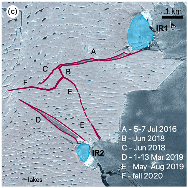
Angelika Humbert, Veit Helm, Niklas Neckel, Ole Zeising, Martin Rückamp, Shfaqat Abbas Khan, Erik Loebel, Jörg Brauchle, Karsten Stebner, Dietmar Gross, Rabea Sondershaus, and Ralf Müller
The Cryosphere, 17, 2851–2870, https://doi.org/10.5194/tc-17-2851-2023, https://doi.org/10.5194/tc-17-2851-2023, 2023
Short summary
Short summary
The largest floating glacier mass in Greenland, the 79° N Glacier, is showing signs of instability. We investigate how crack formation at the glacier's calving front has changed over the last decades by using satellite imagery and airborne data. The calving front is about to lose contact to stabilizing ice islands. Simulations show that the glacier will accelerate as a result of this, leading to an increase in ice discharge of more than 5.1 % if its calving front retreats by 46 %.
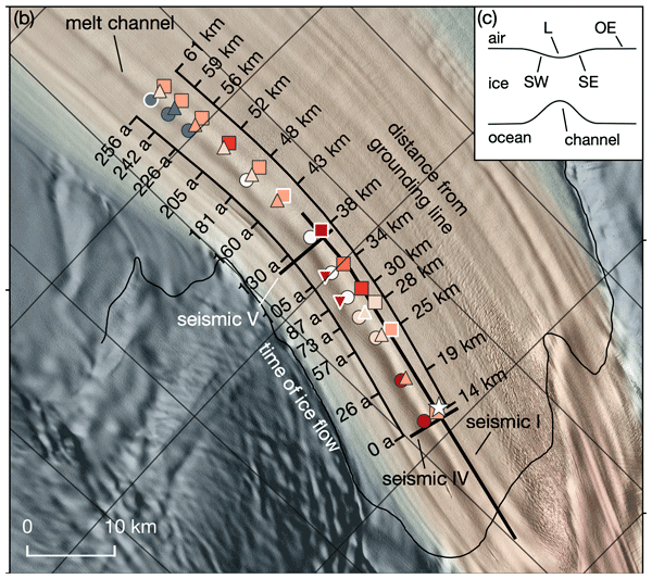
Angelika Humbert, Julia Christmann, Hugh F. J. Corr, Veit Helm, Lea-Sophie Höyns, Coen Hofstede, Ralf Müller, Niklas Neckel, Keith W. Nicholls, Timm Schultz, Daniel Steinhage, Michael Wolovick, and Ole Zeising
The Cryosphere, 16, 4107–4139, https://doi.org/10.5194/tc-16-4107-2022, https://doi.org/10.5194/tc-16-4107-2022, 2022
Short summary
Short summary
Ice shelves are normally flat structures that fringe the Antarctic continent. At some locations they have channels incised into their underside. On Filchner Ice Shelf, such a channel is more than 50 km long and up to 330 m high. We conducted field measurements of basal melt rates and found a maximum of 2 m yr−1. Simulations represent the geometry evolution of the channel reasonably well. There is no reason to assume that this type of melt channel is destabilizing ice shelves.
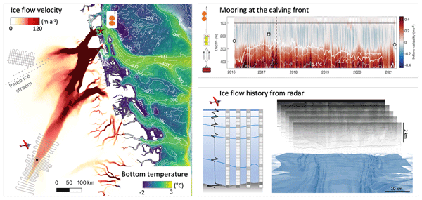
Gerrit Lohmann, Almut Brunner, Gesine Mollenhauer, Christian Haas, Thomas Laepple, Torsten Kanzow, Ilka Weikusat, Monica Ionita, Olaf Eisen, Florian Adolphi, Vera S. N. Schlindwein, Angelika Humbert, Karsten Gohl, Juliane Müller, Klaus Grosfeld, Johann P. Klages, Frank Lamy, Lu Niu, Gregor Knorr, Walter Geibert, Maria Hoerhold, Ingo Sasgen, Daniela Jansen, Rebecca McPherson, Junjie Wu, Xinyue Li, Thomas Krumpen, Hanna Knahl, Helge Goessling, Renate Treffeisen, Peter Köhler, and Thomas Jung
Polarforschung, 94, 69–95, https://doi.org/10.5194/polf-94-69-2026, https://doi.org/10.5194/polf-94-69-2026, 2026
Short summary
Short summary
This paper reviews how the Alfred Wegener Institute studies changes in the ocean and the polar ice regions under climate warming. We bring together results from field observations, laboratory work, and computer models to show how melting ice and changing seas affect global climate and sea level. By combining many approaches, we identify key advances, remaining gaps, and future priorities. Integrating these methods improves our ability to project future climate change and guide decision-making.
Mara Neudert, Daria Paul, Sacha van der Vleuten, Stefanie Arndt, and Christian Haas
EGUsphere, https://doi.org/10.5194/egusphere-2026-5496, https://doi.org/10.5194/egusphere-2026-5496, 2026
Short summary
Short summary
Icebergs can strongly change how snow and ice develop on Antarctic coastal sea ice, but their effects are poorly understood. We combined drone mapping with measurements of snow and ice thickness and ice cores to examine these changes. We found that thick snow on the windward side of icebergs promotes flooding and freezes into solid snow-ice, greatly increasing ice thickness while reducing ice growth from below. Snow-free areas in the lee, in contrast, had thicker ice grown from below.
Julien Meloche, Melody Sandells, Henning Löwe, Nick Rutter, Ghislain Picard, Richard Essery, Randall K. Scharien, Alexandre Langlois, Matthias Jaggi, Josh King, Peter Toose, Michele Scagliola, Jerome Bouffard, Alessandro Di Bella, and Christian Haas
EGUsphere, https://doi.org/10.5194/egusphere-2026-3615, https://doi.org/10.5194/egusphere-2026-3615, 2026
Short summary
Short summary
Sea ice thickness is essential for climate studies. Radar altimetry has provided sea ice thickness measurements, but uncertainty arises from the interaction of the signal with the snow cover. Therefore, modelling the signal interaction with the snow is necessary to improve retrieval. A radar model was used to simulate the radar signal from the snow-covered sea ice. This work paved the way to improved physical algorithms to retrieve snow depth and sea ice thickness for radar altimeter missions.
Valentin Ludwig, Caroline Ribere, Sara Fleury, Christian Haas, Michel Tsamados, Mahmoud El Hajj, Jerome Bouffard, Michele Scagliola, Marion Bocquet, Eric de Boisseson, Vincent Boulenger, Guillaume Boutin, Laurence Connor, Léo Edel, Stefan Hendricks, Ferran Hernández Macià, Marcus Huntemann, Lars Kaleschke, Frank Kauker, Jack Landy, Tom Megain, Alek Petty, Till Soya Rasmussen, Mads Hvid Ribergaard, Robert Ricker, Axel Schweiger, Hoyeon Shi, Xiangshan Tian-Kunze, Donghui Yi, and Alessandro Di Bella
EGUsphere, https://doi.org/10.5194/egusphere-2025-6201, https://doi.org/10.5194/egusphere-2025-6201, 2026
Short summary
Short summary
Our paper compares Arctic sea-ice thickness datasets from models, reanalyses, satellite-only, and multi-product sources. We validate them against Beaufort Sea reference data, compare large-scale products, and analyse time series. Cross-product biases range from 0.2–0.4 m, RMSDs from 0.4–0.9 m, and correlations from 0.5–0.8. We find no 2010–2023 trend, but 1995–2023 thinning of ~ 0.5 m in November and ~ 0.3 m in March.
Lena G. Buth, Thomas Krumpen, Niklas Neckel, Melinda A. Webster, Gerit Birnbaum, Niels Fuchs, Philipp Heuser, Ole Johannsen, and Christian Haas
The Cryosphere, 19, 6527–6545, https://doi.org/10.5194/tc-19-6527-2025, https://doi.org/10.5194/tc-19-6527-2025, 2025
Short summary
Short summary
Arctic sea ice is becoming smoother, raising the question of how these changes affect melt pond coverage and thereby surface albedo. Using airborne imagery and laser altimeter data, we investigated how pressure ridges influence melt ponds. The presence of ridges does not directly control pond fraction, but it does influence pond size distribution and pond geometry. Small ponds have a more complex shape on rough ice than on smooth ice, while the opposite is true for large ponds.
Steven Franke, Mara Neudert, Veit Helm, Arttu Jutila, Océane Hames, Niklas Neckel, Stefanie Arndt, and Christian Haas
The Cryosphere, 19, 6319–6339, https://doi.org/10.5194/tc-19-6319-2025, https://doi.org/10.5194/tc-19-6319-2025, 2025
Short summary
Short summary
Our research explored how icebergs affect the distribution of snow and flooding on Antarctic coastal sea ice. Using aircraft-based radar and laser scanning, we found that icebergs create thick snow drifts on their wind-facing sides and leave snow-free zones in their lee. The weight of these snow drifts often causes the ice below to flood, forming slush. These patterns, driven by wind and iceberg placement, are crucial for understanding sea ice changes and improving climate models.
Christian T. Wild, Reinhard Drews, Niklas Neckel, Joohan Lee, Sihyung Kim, Hyangsun Han, Won Sang Lee, Veit Helm, Sebastian Harry Reid Rosier, Oliver J. Marsh, and Wolfgang Rack
The Cryosphere, 19, 4533–4554, https://doi.org/10.5194/tc-19-4533-2025, https://doi.org/10.5194/tc-19-4533-2025, 2025
Short summary
Short summary
The stability of the Antarctic Ice Sheet depends on how resistance along the sides of large glaciers slows down the flow of ice into the ocean. We present a method to map ice strength using the effect of ocean tides on floating ice shelves. Incorporating weaker ice in shear zones improves the accuracy of model predictions, compared with satellite observations. This demonstrates the untapped potential of radar satellites to map ice stiffness in the most critical areas for ice sheet stability.
Angelika Humbert, Veit Helm, Ole Zeising, Niklas Neckel, Matthias H. Braun, Shfaqat Abbas Khan, Martin Rückamp, Holger Steeb, Julia Sohn, Matthias Bohnen, and Ralf Müller
The Cryosphere, 19, 3009–3032, https://doi.org/10.5194/tc-19-3009-2025, https://doi.org/10.5194/tc-19-3009-2025, 2025
Short summary
Short summary
We study the evolution of a massive lake on the Greenland Ice Sheet using satellite and airborne data and some modelling. The lake is emptying rapidly. Water flows to the glacier's base through cracks and triangular-shaped moulins that remain visible over the years. Some of them become reactivated. We find features inside the glacier that stem from drainage events with a width of even 1 km. These features are persistent over the years, although they are changing in shape.
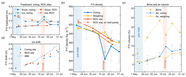
Evgenii Salganik, Odile Crabeck, Niels Fuchs, Nils Hutter, Philipp Anhaus, and Jack Christopher Landy
The Cryosphere, 19, 1259–1278, https://doi.org/10.5194/tc-19-1259-2025, https://doi.org/10.5194/tc-19-1259-2025, 2025
Short summary
Short summary
To measure Arctic ice thickness, we often check how much ice sticks out of the water. This method depends on knowing the ice's density, which drops significantly in summer. Our study, validated with sonar and laser data, shows that these seasonal changes in density can complicate melt measurements. We stress the importance of considering these density changes for more accurate ice thickness readings.
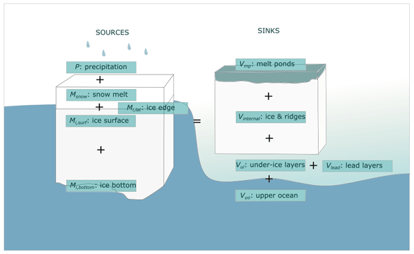
Madison M. Smith, Niels Fuchs, Evgenii Salganik, Donald K. Perovich, Ian Raphael, Mats A. Granskog, Kirstin Schulz, Matthew D. Shupe, and Melinda Webster
The Cryosphere, 19, 619–644, https://doi.org/10.5194/tc-19-619-2025, https://doi.org/10.5194/tc-19-619-2025, 2025
Short summary
Short summary
The fate of freshwater from Arctic sea ice and snowmelt impacts interactions of the atmosphere, sea ice, and ocean. We complete a comprehensive analysis of datasets from a 2020 central Arctic field campaign to understand the drivers of the sea ice freshwater budget and the fate of this water. Over half of the freshwater comes from surface melt, and a majority fraction is incorporated into the ocean. Results suggest that the representation of melt ponds is a key area for future development.
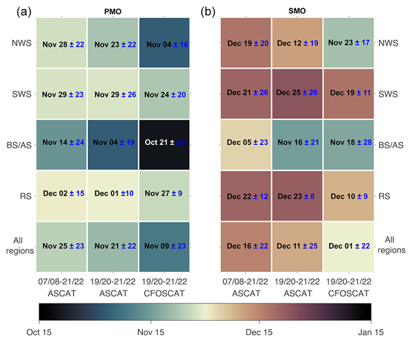
Rui Xu, Chaofang Zhao, Stefanie Arndt, and Christian Haas
The Cryosphere, 18, 5769–5788, https://doi.org/10.5194/tc-18-5769-2024, https://doi.org/10.5194/tc-18-5769-2024, 2024
Short summary
Short summary
The onset of snowmelt on Antarctic sea ice is an important indicator of sea ice change. In this study, we used two radar scatterometers to detect the onset of snowmelt on perennial Antarctic sea ice. Results show that since 2007, snowmelt onset has demonstrated strong interannual and regional variabilities. We also found that the difference in snowmelt onsets between the two scatterometers is closely related to snow metamorphism.
Yi Zhou, Xianwei Wang, Ruibo Lei, Arttu Jutila, Donald K. Perovich, Luisa von Albedyll, Dmitry V. Divine, Yu Zhang, and Christian Haas
EGUsphere, https://doi.org/10.5194/egusphere-2024-2821, https://doi.org/10.5194/egusphere-2024-2821, 2024
Preprint archived
Short summary
Short summary
This study examines how the bulk density of Arctic sea ice varies seasonally, a factor often overlooked in satellite measurements of sea ice thickness. From October to April, we found significant seasonal variations in sea ice bulk density at different spatial scales using direct observations as well as airborne and satellite data. New models were then developed to indirectly predict sea ice bulk density. This advance can improve our ability to monitor changes in Arctic sea ice.
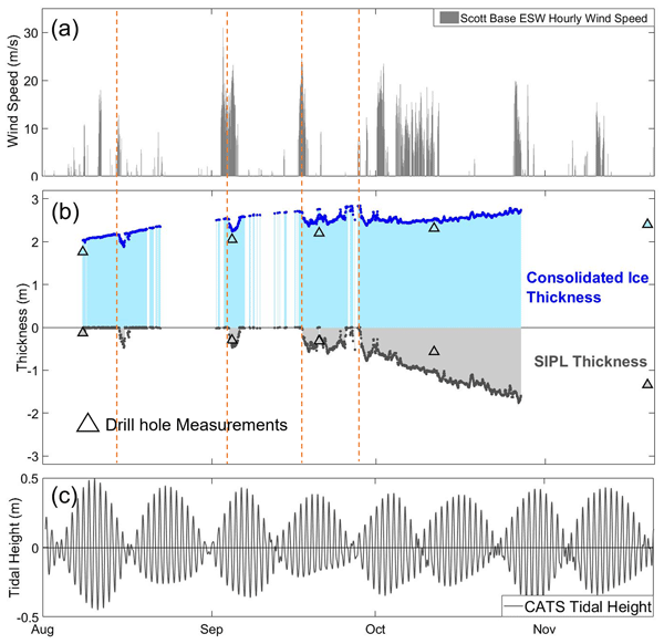
Gemma M. Brett, Greg H. Leonard, Wolfgang Rack, Christian Haas, Patricia J. Langhorne, Natalie J. Robinson, and Anne Irvin
The Cryosphere, 18, 3049–3066, https://doi.org/10.5194/tc-18-3049-2024, https://doi.org/10.5194/tc-18-3049-2024, 2024
Short summary
Short summary
Glacial meltwater with ice crystals flows from beneath ice shelves, causing thicker sea ice with sub-ice platelet layers (SIPLs) beneath. Thicker sea ice and SIPL reveal where and how much meltwater is outflowing. We collected continuous measurements of sea ice and SIPL. In winter, we observed rapid SIPL growth with strong winds. In spring, SIPLs grew when tides caused offshore circulation. Wind-driven and tidal circulation influence glacial meltwater outflow from ice shelf cavities.
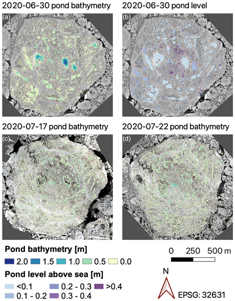
Niels Fuchs, Luisa von Albedyll, Gerit Birnbaum, Felix Linhardt, Natascha Oppelt, and Christian Haas
The Cryosphere, 18, 2991–3015, https://doi.org/10.5194/tc-18-2991-2024, https://doi.org/10.5194/tc-18-2991-2024, 2024
Short summary
Short summary
Melt ponds are key components of the Arctic sea ice system, yet methods to derive comprehensive pond depth data are missing. We present a shallow-water bathymetry retrieval to derive this elementary pond property at high spatial resolution from aerial images. The retrieval method is presented in a user-friendly way to facilitate replication. Furthermore, we provide pond properties on the MOSAiC expedition floe, giving insights into the three-dimensional pond evolution before and after drainage.
Yi Zhou, Xianwei Wang, Ruibo Lei, Luisa von Albedyll, Donald K. Perovich, Yu Zhang, and Christian Haas
EGUsphere, https://doi.org/10.5194/egusphere-2024-1240, https://doi.org/10.5194/egusphere-2024-1240, 2024
Preprint archived
Short summary
Short summary
This study examines how the density of Arctic sea ice varies seasonally, a factor often overlooked in satellite measurements of sea ice thickness. From October to April, using direct observations and satellite data, we found that sea ice density decreases significantly until mid-January due to increased porosity as the ice ages, and then stabilizes until April. We then developed new models to estimate sea ice density. This advance can improve our ability to monitor changes in Arctic sea ice.

Karl Kortum, Suman Singha, Gunnar Spreen, Nils Hutter, Arttu Jutila, and Christian Haas
The Cryosphere, 18, 2207–2222, https://doi.org/10.5194/tc-18-2207-2024, https://doi.org/10.5194/tc-18-2207-2024, 2024
Short summary
Short summary
A dataset of 20 radar satellite acquisitions and near-simultaneous helicopter-based surveys of the ice topography during the MOSAiC expedition is constructed and used to train a variety of deep learning algorithms. The results give realistic insights into the accuracy of retrieval of measured ice classes using modern deep learning models. The models able to learn from the spatial distribution of the measured sea ice classes are shown to have a clear advantage over those that cannot.
Ole Zeising, Niklas Neckel, Nils Dörr, Veit Helm, Daniel Steinhage, Ralph Timmermann, and Angelika Humbert
The Cryosphere, 18, 1333–1357, https://doi.org/10.5194/tc-18-1333-2024, https://doi.org/10.5194/tc-18-1333-2024, 2024
Short summary
Short summary
The 79° North Glacier in Greenland has experienced significant changes over the last decades. Due to extreme melt rates, the ice has thinned significantly in the vicinity of the grounding line, where a large subglacial channel has formed since 2010. We attribute these changes to warm ocean currents and increased subglacial discharge from surface melt. However, basal melting has decreased since 2018, indicating colder water inflow into the cavity below the glacier.
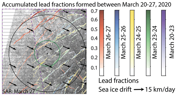
Luisa von Albedyll, Stefan Hendricks, Nils Hutter, Dmitrii Murashkin, Lars Kaleschke, Sascha Willmes, Linda Thielke, Xiangshan Tian-Kunze, Gunnar Spreen, and Christian Haas
The Cryosphere, 18, 1259–1285, https://doi.org/10.5194/tc-18-1259-2024, https://doi.org/10.5194/tc-18-1259-2024, 2024
Short summary
Short summary
Leads (openings in sea ice cover) are created by sea ice dynamics. Because they are important for many processes in the Arctic winter climate, we aim to detect them with satellites. We present two new techniques to detect lead widths of a few hundred meters at high spatial resolution (700 m) and independent of clouds or sun illumination. We use the MOSAiC drift 2019–2020 in the Arctic for our case study and compare our new products to other existing lead products.
Angelika Humbert, Veit Helm, Niklas Neckel, Ole Zeising, Martin Rückamp, Shfaqat Abbas Khan, Erik Loebel, Jörg Brauchle, Karsten Stebner, Dietmar Gross, Rabea Sondershaus, and Ralf Müller
The Cryosphere, 17, 2851–2870, https://doi.org/10.5194/tc-17-2851-2023, https://doi.org/10.5194/tc-17-2851-2023, 2023
Short summary
Short summary
The largest floating glacier mass in Greenland, the 79° N Glacier, is showing signs of instability. We investigate how crack formation at the glacier's calving front has changed over the last decades by using satellite imagery and airborne data. The calving front is about to lose contact to stabilizing ice islands. Simulations show that the glacier will accelerate as a result of this, leading to an increase in ice discharge of more than 5.1 % if its calving front retreats by 46 %.
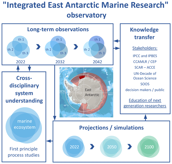
Julian Gutt, Stefanie Arndt, David Keith Alan Barnes, Horst Bornemann, Thomas Brey, Olaf Eisen, Hauke Flores, Huw Griffiths, Christian Haas, Stefan Hain, Tore Hattermann, Christoph Held, Mario Hoppema, Enrique Isla, Markus Janout, Céline Le Bohec, Heike Link, Felix Christopher Mark, Sebastien Moreau, Scarlett Trimborn, Ilse van Opzeeland, Hans-Otto Pörtner, Fokje Schaafsma, Katharina Teschke, Sandra Tippenhauer, Anton Van de Putte, Mia Wege, Daniel Zitterbart, and Dieter Piepenburg
Biogeosciences, 19, 5313–5342, https://doi.org/10.5194/bg-19-5313-2022, https://doi.org/10.5194/bg-19-5313-2022, 2022
Short summary
Short summary
Long-term ecological observations are key to assess, understand and predict impacts of environmental change on biotas. We present a multidisciplinary framework for such largely lacking investigations in the East Antarctic Southern Ocean, combined with case studies, experimental and modelling work. As climate change is still minor here but is projected to start soon, the timely implementation of this framework provides the unique opportunity to document its ecological impacts from the very onset.
Angelika Humbert, Julia Christmann, Hugh F. J. Corr, Veit Helm, Lea-Sophie Höyns, Coen Hofstede, Ralf Müller, Niklas Neckel, Keith W. Nicholls, Timm Schultz, Daniel Steinhage, Michael Wolovick, and Ole Zeising
The Cryosphere, 16, 4107–4139, https://doi.org/10.5194/tc-16-4107-2022, https://doi.org/10.5194/tc-16-4107-2022, 2022
Short summary
Short summary
Ice shelves are normally flat structures that fringe the Antarctic continent. At some locations they have channels incised into their underside. On Filchner Ice Shelf, such a channel is more than 50 km long and up to 330 m high. We conducted field measurements of basal melt rates and found a maximum of 2 m yr−1. Simulations represent the geometry evolution of the channel reasonably well. There is no reason to assume that this type of melt channel is destabilizing ice shelves.
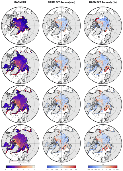
Klaus Dethloff, Wieslaw Maslowski, Stefan Hendricks, Younjoo J. Lee, Helge F. Goessling, Thomas Krumpen, Christian Haas, Dörthe Handorf, Robert Ricker, Vladimir Bessonov, John J. Cassano, Jaclyn Clement Kinney, Robert Osinski, Markus Rex, Annette Rinke, Julia Sokolova, and Anja Sommerfeld
The Cryosphere, 16, 981–1005, https://doi.org/10.5194/tc-16-981-2022, https://doi.org/10.5194/tc-16-981-2022, 2022
Short summary
Short summary
Sea ice thickness anomalies during the MOSAiC (Multidisciplinary drifting Observatory for the Study of Arctic Climate) winter in January, February and March 2020 were simulated with the coupled Regional Arctic climate System Model (RASM) and compared with CryoSat-2/SMOS satellite data. Hindcast and ensemble simulations indicate that the sea ice anomalies are driven by nonlinear interactions between ice growth processes and wind-driven sea-ice transports, with dynamics playing a dominant role.
Arttu Jutila, Stefan Hendricks, Robert Ricker, Luisa von Albedyll, Thomas Krumpen, and Christian Haas
The Cryosphere, 16, 259–275, https://doi.org/10.5194/tc-16-259-2022, https://doi.org/10.5194/tc-16-259-2022, 2022
Short summary
Short summary
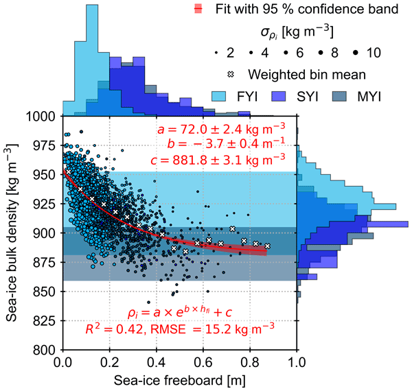
Sea-ice thickness retrieval from satellite altimeters relies on assumed sea-ice density values because density cannot be measured from space. We derived bulk densities for different ice types using airborne laser, radar, and electromagnetic induction sounding measurements. Compared to previous studies, we found high bulk density values due to ice deformation and younger ice cover. Using sea-ice freeboard, we derived a sea-ice bulk density parameterisation that can be applied to satellite data.
Cited articles
Agisoft LLC: Agisoft Metashape User Manual Professional Edition, Version 1.7, https://www.agisoft.com/pdf/metashape-pro_1_7_en.pdf (last access: 17 November 2026), 2021. a
Deems, J. S., Painter, T. H., and Finnegan, D. C.: Lidar measurement of snow depth: a review, J. Glaciol., 59, 467–479, https://doi.org/10.3189/2013jog12j154, 2013. a
Drews, R., Rack, W., Wesche, C., and Helm, V.: A Spatially Adjusted Elevation Model in Dronning Maud Land, Antarctica, Based on Differential SAR Interferometry, IEEE T. Geosci. Remote, 47, 2501–2509, https://doi.org/10.1109/TGRS.2009.2016081, 2009. a
Elias, M., Isfort, S., Eltner, A., and Maas, H.-G.: UAS Photogrammetry for Precise Digital Elevation Models of Complex Topography: A Strategy Guide, ISPRS Ann. Photogramm. Remote Sens. Spatial Inf. Sci., X-2-2024, 57–64, https://doi.org/10.5194/isprs-annals-X-2-2024-57-2024, 2024. a
Fetterer, F. and Untersteiner, N.: Observations of melt ponds on Arctic sea ice, J. Geophys. Res.-Oceans, 103, 24821–24835, https://doi.org/10.1029/98JC02034, 1998. a
Fuchs, N.: A multidimensional analysis of sea ice melt pond properties from aerial images, PhD thesis, University of Bremen, https://doi.org/10.26092/elib/2249, 2023. a
Fuchs, N., von Albedyll, L., Birnbaum, G., Linhardt, F., Oppelt, N., and Haas, C.: Sea ice melt pond bathymetry reconstructed from aerial photographs using photogrammetry: a new method applied to MOSAiC data, The Cryosphere, 18, 2991–3015, https://doi.org/10.5194/tc-18-2991-2024, 2024. a, b, c
Hann, R., Enache, A., Nielsen, M. C., Stovner, B. N., van Beeck, J., Johansen, T. A., and Borup, K. T.: Experimental Heat Loads for Electrothermal Anti-Icing and De-Icing on UAVs, Aerospace, 8, https://doi.org/10.3390/aerospace8030083, 2021. a
Hyun, C.-U., Kim, J.-H., Han, H., and Kim, H.-C.: Mosaicking Opportunistically Acquired Very High-Resolution Helicopter-Borne Images over Drifting Sea Ice Using COTS Sensors, Sensors, 19, https://doi.org/10.3390/s19051251, 2019. a
Itkin, P., Hendricks, S., Webster, M., von Albedyll, L., Arndt, S., Divine, D., Jaggi, M., Oggier, M., Raphael, I., Ricker, R., Rohde, J., Schneebeli, M., and Liston, G. E.: Sea ice and snow characteristics from year-long transects at the MOSAiC Central Observatory, Elem. Sci. Anth., 11, 00048, https://doi.org/10.1525/elementa.2022.00048, 2023. a, b
Kolar, J., Neckel, N., Rückert, J. E., Bühler, L., Bahlmann, J., Risse, N., Hendricks, S., and Neudert, M.: Ice and snow thickness measurements from the ArcWatch-2 Expedition, PANGAEA [data set], https://doi.org/10.1594/PANGAEA.984304, 2025. a, b
Landy, J. C., Isleifson, D., Komarov, A. S., and Barber, D. G.: Parameterization of Centimeter-Scale Sea Ice Surface Roughness Using Terrestrial LiDAR, IEEE T. Geosci. Remote, 53, 1271–1286, https://doi.org/10.1109/TGRS.2014.2336833, 2015. a
Neckel, N.: MAVIC3GRID (Version 1), Zenodo [code], https://doi.org/10.5281/zenodo.23910871, 2026. a
Neckel, N., Zeising, O., Steinhage, D., Helm, V., and Humbert, A.: Seasonal Observations at 79° N Glacier (Greenland) From Remote Sensing and in situ Measurements, Front. Earth Sci., 8, https://doi.org/10.3389/feart.2020.00142, 2020. a
Neckel, N., Fuchs, N., Birnbaum, G., Hutter, N., Jutila, A., Buth, L., von Albedyll, L., Ricker, R., and Haas, C.: Helicopter-borne RGB orthomosaics and photogrammetric digital elevation models from the MOSAiC Expedition, Sci. Data, 10, 426, https://doi.org/10.1038/s41597-023-02318-5, 2023. a
Neckel, N., Fuchs, N., Kolar, J., Kordes, T., and Haas, C.: UAV based orthomosaics and ice surface models from the ArcWatch-2 Expedition, PANGAEA [data set], https://doi.org/10.1594/PANGAEA.984115, 2025a. a, b
Neckel, N., Kolar, J., Bühler, L., Bahlmann, J., Rückert, J. E., Trace-Kleeberg, S., and Risse, N.: GNSS measurements of PS144 ice stations, PANGAEA [data set], https://doi.org/10.1594/PANGAEA.983769, 2025b. a, b
Neudert, M., Arndt, S., Hendricks, S., Hoppmann, M., Schulze, M., and Haas, C.: Improved sub-ice platelet layer mapping with multi-frequency EM induction sounding, J. Appl. Geophys., 230, 105540, https://doi.org/10.1016/j.jappgeo.2024.105540, 2024. a
Rabe, B. and Geibert, W.: The Expedition PS144 of the Research Vessel POLARSTERN to the Arctic Ocean in 2024, in: Reports on polar and marine research, Bremerhaven, edited by: Bornemann, H. and Amir Sawadkuhi, S., Alfred-Wegener-Institut Helmholtz-Zentrum für Polar- und Meeresforschung, 794, 1–312, https://doi.org/10.57738/BzPM_0794_2025, 2025. a
Steer, A. and Divine, D.: Sea ice stations orthophotos and digital elevation models from drone -based aerial surveys conducted during Nansen Legacy cruises to the northern Barents Sea and the area north of Svalbard in 2021–2022, Norwegian Polar Institute [data set], https://doi.org/10.21334/NPOLAR.2024.36C62B06, 2024. a
Tétreault, P., Kouba, J., Héroux, P., and Legree, P.: CSRS-PPP: An internet service for GPS user access to the Canadian Spatial Reference frame, Geomatica, 59, 17–28, 2005. a
Warren, S. G.: Optical properties of snow, Rev. Geophys., 20, 67–89, https://doi.org/10.1029/RG020i001p00067, 1982. a
Short summary
We present challenges and solutions for UAV (Unmanned Aerial Vehicle) mapping of drifting Arctic pack ice at high latitudes. We develop and evaluate a drift-corrected workflow for autonomous grid missions, enabling void-free orthomosaics and DEMs (Digital Elevation Models) from SfM (Structure from Motion) photogrammetry. Applied during the ArcWatch-2 expedition, the approach also integrates drone-based laser scanning and drifting GNSS (Global Navigation Satellite System) stations. We demonstrate applications including ice-thickness estimation, surface classification, and melt pond depth retrieval.
We present challenges and solutions for UAV (Unmanned Aerial Vehicle) mapping of drifting Arctic...


